Last
updated: 8 November 2011.
The 19 central maps of this site, emphasized the waxing and waning
of the Roman Empire over 18 centuries, from 338 BC to 1453 AD. By
contrast, the 5 "summary" maps of this page emphasize the territorial
continuity
of the Empire over its middle 1350 years (3/4 of its life). In this
period,
from 146 BC to 1204 AD, it could always claim the title of being
the greatest and wealthiest state in the northern Mediterranean. By "a
power in the northern Mediterranean" I mean a state with its political
centre in Europe or Asia Minor or Syria. The greatness of the
Roman
Empire in this period can be quantified by the population of its
largest
city, Rome or New Rome. Its wealth can be quantified by its state
budget.
The first statistic is estimated (with wide variation) in a number of
sources.
The latter is not so; my claims are merely guesses informed largely by
Treadgold (1997).
This period of greatness of the Roman Empire began with the annexation of Macedonia in 148 BC and Carthage and Greece in 146 BC. By these acts the Empire absorbed its only rivals in the Mediterranean and surpassed its only rival in Asia, the Selucid Kingdom centred on Antioch in Syria. The latter, a successor kingdom to Alexander's Empire, had once stretched from Thrace to the borders of India, but by this time was reduced to Syria, Palestine and Mesopotamia. The low point of Roman fortunes was around 755, when the Umayyad Caliphate in Spain would have been a rival for the title I have invented. However, its capital Cordoba was only half the size of Constantinople. The period of greatness definitively ended in 1204 when Constantinople fell to the fourth Crusade. Around the same time, the Holy Roman Empire had ceased to be the dominant state in Western Christendom. Its authority in Italy had crumbled, with the Papacy and the Lombard cities acting as independent states, and cultural dominance had passed to France.
One way to summarize the territory of the Roman Empire in its 1350 years of greatness is to consider how long various areas were under its control. The below map shows the result of doing this. The pale purple shows areas that were part of the Roman Empire at any time during this period. The intermediate purple shows areas that were Roman for a time (not necessarily continuously) for at least half this period (675 years). For the purpose of determining this time, areas owing allegiance, rather than belonging, to the Roman Empire are counted at half the rate. The deep purple shows areas that were Roman for the whole time (barring short-lived rebellions).
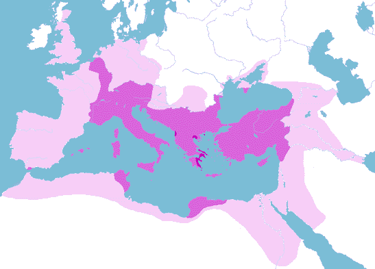
The pale purple region is significantly greater than the Empire at its maximum extent (in 116 AD) only in central Europe. Interestingly, the intermediate purple region is situated fairly centrally within this, and includes both Rome and New Rome. The deep purple areas are just a few scraps: extreme south-west Greece, and around Thessalonica and Dyrrachium. Their extent is determined by the (relative) minimum of the Empire in 755. They are likewise situated fairly centrally within the intermediate purple region, between Rome and Constantinople, but including neither. On the basis of this map alone, someone ignorant of Roman history would probably guess that Greece was the centre of the Empire, when in fact it was a back-water for most of the time.
Another way to summarize Roman history in this period is to look at the 5 maps used in the introductory page. These (which are reproduced in larger versions in the 19 maps page) showed 5 maxima of the Empire which span the period of greatness: in the AD years 9, 336, 564, 812, and 1040. In these maps, no distinction is made between areas belonging directly to the Empire, and those owing allegiance to it. From these maps, it is easy to determine which regions were part of the Empire at all 5 of those times (deep purple), or for 4 out of 5 (intermediate purple), or 3 out of 5 (pale purple). The last region is not much smaller than the region that was in the Empire at any of the times, which is why I have stopped at that point.

The pale purple region in this map is not much smaller than the same-coloured "any-time" region in the first map, whereas here it represents merely the "most of the time" region (which in the first map is coloured in intermediate purple). The "every time" deep purple region here is hugely larger than the corresponding (and same-coloured) region in the first map. All of this reflects the inflated picture of the Empire's power one would form from considering it only at its peaks. More interesting is the fact that the two maps agree in the impression they give of what was the core, and what the periphery, of the Empire over this 1350 years. As for the first map, a total ignoramus with respect to Roman history would probably guess from this map that the centre of the Roman Empire was Greece, and that its core extended to Italy and Anatolia and somewhat beyond. Note in particular that the intermediate purple regions in the two maps are very similar.
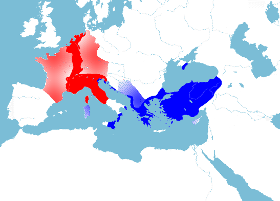
The similarity of the two regions coloured intermediate purple in the above two maps suggests that it would be worth looking in more detail at these regions, as a way of summarizing the Roman Empire in its period of greatness. Below I reproduce that region from map 1, but coloured red or blue depending on whether (in the period 146 BC - 1204 AD) it was more often part of the Western or Eastern Empire. The two capitals, Rome and Constantinople, are shown as black dots. For times when both Rome and Constantinople were political centres of one Empire, all regions are counted equally to West and East. Regions owing allegiance are counted with half weighting.
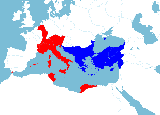
The result of this colouring is an Eastern Empire that is compact, and corresponds well to the Byzantine Empire at its height in c.1040. By contrast, the Western Empire is more far-flung, and does not correspond well to a Roman Empire at any stage in history. Together, the two Empires stretch from the Euphrates to the Atlantic, and the North Sea to the Sahara.
Applying an analogous procedure to the intermediate purple region in map 2 yields the map below. Again, the colour red or blue is used depending on whether (in the years AD 9, 564, 812, 1040) an area was more often part of the Western or Eastern Empire. The year 336 is not used in this computation, as Rome and Constantinople were then both political centres of one Empire.
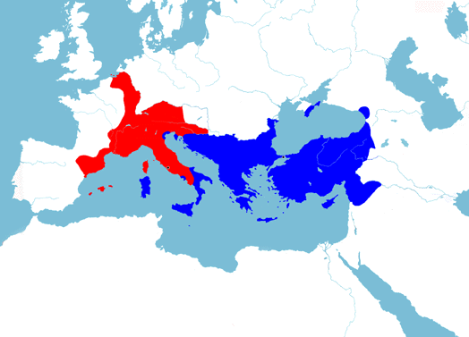
Once again, the result of this colouring is an Eastern Empire that is compact, and corresponds well to the Byzantine Empire at its height in c.1040. The Western Empire this time is smaller, and somewhat more compact. The two Empires together stretch from the North Sea to the Euphrates.
It is a subjective but interesting exercise to create one map that includes the common features of maps 3 and 4, and selects between the uncommon features so as to produce sensible-looking frontiers for an Eastern and Western Empire. The result, which one might expect to reflect "typical" frontiers of the Roman Empires, appears below.
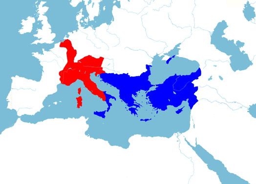
The Eastern Empire here is almost identical to the Byzantine Empire at its height in c.1040. Almost any Emperor in Constantinople from about 650 onward would have been happy to rule over an Empire of this extent. The Western Empire is substantially smaller than the Eastern, is quite compact, and has a very rough correspondence with the Holy Roman Empire in c.1040. This lesser similarity is due to the fact that Germany beyond the Rhine and Danube (which formed a large part of the Holy Roman Empire) was not part of the Roman Empire of the early centuries AD. As in map 4, the two Empires together stretch from the North Sea to the Euphrates.
From the above discussion, it might be thought that the Western Empire in map 5 bears little relation to any historical Roman Empire. In particular, the extrusion of territory along the left bank of the Rhine is not a feature of any of the 19 historical maps in the main page. However, one should not be too hasty to dismiss it as an artifice. At another point in history, there was a Western Empire with many of the features of that in map 5. This time was 843-855 AD.
In 812, Charlemagne was succeeded by his son, Louis the Pious, who
reigned
as Emperor until 840. However Louis' sons were warring with each other,
and
him, from 830 onwards. In 843, his three remaining sons partitioned the
Empire. The eldest, Lothair, kept the Imperial title he had been
granted
by Louis in 817, and had nominal suzerainty over his brothers. But he
directly
ruled only the central part of the Empire: Italy, Burgundy, and the
left
bank of the Rhine. By 1033 all of this area had been reunited with
Germany
in the Holy Roman Empire, while France went its separate way. But this
statement gives no hint of the complexity of the process. The
intervening
years saw numerous redrawings of the boundaries involving Lothair's
"Middle
Kingdom", in 855, 863, 870, 876, 877, 880, 882, 884, 888, 911, 925,
934, and 960. If
dynastic
history had been slightly different, it is quite possible that the
Carolingian
Empire would have given rise to a Western Roman Empire similar to that
shown in map 5.