Regarding the second purpose, one thing can be said with certainty about these reconstructions: they are wrong. Drawing sharp lines on a map requires more hard information than exists for these periods of time, especially for the early maps. For the later maps (660, 942), the evidence is far better and the broad outlines are certainly correct. But historians still disagree substantially on the location of some borders. Like my reconstruction using the primary sources, all that can be said is that they are no less plausible than many other reconstructions. The maps are also likely to be wrong in assuming a smaller number of states than actually existed. This is likely because in the one area where reliable records are available, Wales, the size of states was quite small. No doubt this was partly due to poor communications in mountainous terrain. Nevertheless it is likely that states outside Wales, and especially in the equally mountainous North, were smaller than those shown on the maps. It is natural that evidence for the existence of small Briton states in areas later taken over by the English would disappear. English states were quite probably smaller and more numerous as well.
The "ethnicity" of the ruling groups in these states is also sure to be more complicated than as shown in the maps. For instance, I have non-critically taken Bede's division of the English into Angles, Saxons and Jutes at face value, where others would question whether these distinctions had any meaning to the Germanic settlers in the fifth and sixth centuries. Even at the time of the last map (942), Bernicia (which I have coloured as an Angle state following Bede) was referred to as "North Saxonia" by a continental traveller.
Another anachronism in these maps is the names of states. Except for the latin names of tribes (attached to the civitates of Roman Britain), I have not necessarily labelled states using the names by which they would have been known at the time. Some names are later forms, e.g. "Gwynedd" was the much later (even than 942) form of Venedotia, first attested on a gravestone c.500. Other names are fictions of mine, e.g. "Verulam" in 530, which I have derived from its chief city, Verulamium. Others were not invented by me, but are nevertheless of doubtful authenticity, deriving from late traditions (e.g. "Theyernllwg"). Names in these last two categories, which are not well attested for any time period, I have written in italics.
A final note: in what follows, "Britannia" refers to the area shown
on the maps. That is, the Island south of the Forth-Clyde line. This is
the area occupied by Rome and its federate allies for most of the first
four centuries A.D.
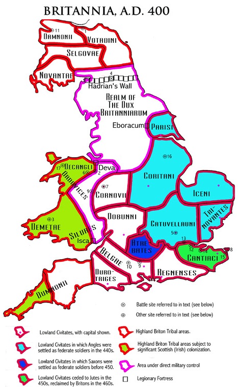 This map shows the reasonably well
established boundaries of the
civitates
(city-states) of Britannia at the end of the Roman era, as well as the
more speculative boundaries of military districts and highland tribes.
These political boundaries may have remained relatively unchanged right
up until the revolt of the English soldier-settlers (which I have
placed
in the 470s). Also shown are the states in which these Angles, Saxons
and
Jutes were settled in the 5th century as federate soldiers.
This map shows the reasonably well
established boundaries of the
civitates
(city-states) of Britannia at the end of the Roman era, as well as the
more speculative boundaries of military districts and highland tribes.
These political boundaries may have remained relatively unchanged right
up until the revolt of the English soldier-settlers (which I have
placed
in the 470s). Also shown are the states in which these Angles, Saxons
and
Jutes were settled in the 5th century as federate soldiers.
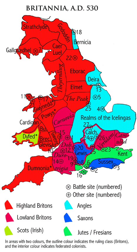 After the English
revolt, Britannia was certainly in a state of flux,
as
Gildas attests. The situation restabilized after the Britons' victory
at
Badon, which I have placed in 518. The map for 530 shows the partition
of Britain between Britons and English. This was about the time at
which
Procopius described Britain as being inhabited by three peoples:
Angles,
Frisians, and Britons, each with one king. It was also just before the
Gewissae took the Isle of Wight from the Jutes, in 530 according to the
Anglo-Saxon chronicle. Although the Britons had already lost most of
lowland
Britannia to the English, Britannia as a whole was still overwhelmingly
controlled by Britons. Also shown in this map are the possible
identities
of the kingdoms of the five kings of Gildas, (with Gwynedd split
between
Maglocunus and Cuneglasus). It can be seen that these kingdoms are the
four largest highland Briton kingdoms of Southern Britannia, and as
such
these kings may have been the chief potentates with which Gildas
(probably
located in Durotrigia) would have been concerned, in around 545.
After the English
revolt, Britannia was certainly in a state of flux,
as
Gildas attests. The situation restabilized after the Britons' victory
at
Badon, which I have placed in 518. The map for 530 shows the partition
of Britain between Britons and English. This was about the time at
which
Procopius described Britain as being inhabited by three peoples:
Angles,
Frisians, and Britons, each with one king. It was also just before the
Gewissae took the Isle of Wight from the Jutes, in 530 according to the
Anglo-Saxon chronicle. Although the Britons had already lost most of
lowland
Britannia to the English, Britannia as a whole was still overwhelmingly
controlled by Britons. Also shown in this map are the possible
identities
of the kingdoms of the five kings of Gildas, (with Gwynedd split
between
Maglocunus and Cuneglasus). It can be seen that these kingdoms are the
four largest highland Briton kingdoms of Southern Britannia, and as
such
these kings may have been the chief potentates with which Gildas
(probably
located in Durotrigia) would have been concerned, in around 545.
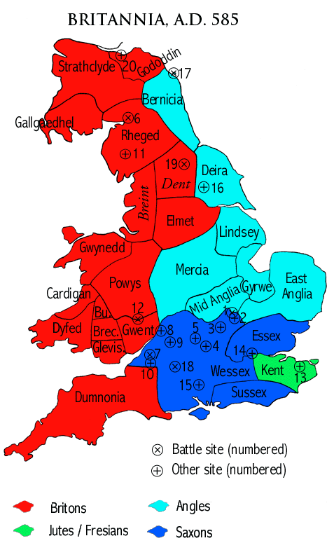 The political situation in
Britannia remained relatively stable for about
50 years after Badon, then changed radically in the following 20. By
585
all of the major lowland Briton states, the descendants of the Roman
civitates,
had fallen into English hands. The highland Britons were not yet
seriously
threatened, and still controlled about half of Britannia. All of the
major
Mediaeval English kingdoms had already appeared at this stage, except
for
Northumbria which had not been formed from the union of Bernicia and
Deira.
At this time, Wessex under Ceawlin was at a peak of its power, not
reached
again until the 9th century.
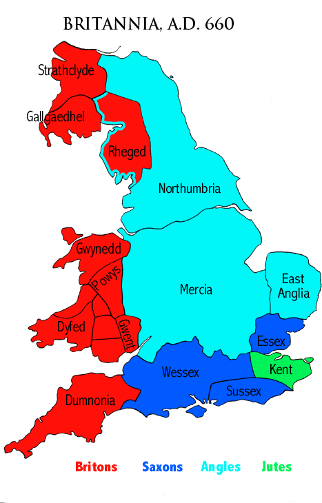
During the 7th century, the
English continued to advance at the expense
of the Britons. By this time (660), the Britons' political control had
been pushed back to the three Western peninsulas of Britannia: Dumnonia
(now Devon and Cornwall ), Wales, and Strathclyde-Galloway (now
South-West
Scotland). The status of Rheged is uncertain, but it was probably under
effective Northumbrian control. Shortly after this time the West Saxons
began settlement around Exeter, in the heart of Dumnonia. Nevertheless,
Cornwall was not finally absorbed by Wessex until the 10th century.
Wales
was not conquered by the English (under Norman rule) until the late
13th
century (and was even independent again, briefly, in the 15th century).
Strathclyde-Galloway was peacefully incorporated into the Scottish
kingdom
in the 11th century. Thus, 660 marks the effective end of the rapid
advance
of the English at the expense of the Britons. This time was also the
beginning
of the supremacy of Mercia among the English kingdoms. In later
centuries,
it annexed most of the smaller kingdoms, and substantial parts of
Northumbria
and Wessex as well.
The political situation in
Britannia remained relatively stable for about
50 years after Badon, then changed radically in the following 20. By
585
all of the major lowland Briton states, the descendants of the Roman
civitates,
had fallen into English hands. The highland Britons were not yet
seriously
threatened, and still controlled about half of Britannia. All of the
major
Mediaeval English kingdoms had already appeared at this stage, except
for
Northumbria which had not been formed from the union of Bernicia and
Deira.
At this time, Wessex under Ceawlin was at a peak of its power, not
reached
again until the 9th century.
During the 7th century, the
English continued to advance at the expense
of the Britons. By this time (660), the Britons' political control had
been pushed back to the three Western peninsulas of Britannia: Dumnonia
(now Devon and Cornwall ), Wales, and Strathclyde-Galloway (now
South-West
Scotland). The status of Rheged is uncertain, but it was probably under
effective Northumbrian control. Shortly after this time the West Saxons
began settlement around Exeter, in the heart of Dumnonia. Nevertheless,
Cornwall was not finally absorbed by Wessex until the 10th century.
Wales
was not conquered by the English (under Norman rule) until the late
13th
century (and was even independent again, briefly, in the 15th century).
Strathclyde-Galloway was peacefully incorporated into the Scottish
kingdom
in the 11th century. Thus, 660 marks the effective end of the rapid
advance
of the English at the expense of the Britons. This time was also the
beginning
of the supremacy of Mercia among the English kingdoms. In later
centuries,
it annexed most of the smaller kingdoms, and substantial parts of
Northumbria
and Wessex as well.
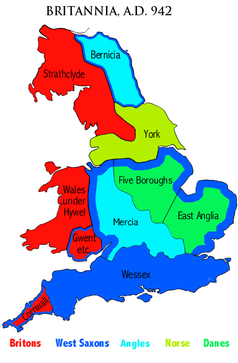 The final map, for 942, is long after
the period covered by my
narrative
of the Ruin and Conquest of Britain. I have included it primarily
because
it shows an interesting time in the history of Britain. Following the
Viking
invasions in the 9th century, the kingdom of Wessex was left as the
only
English kingdom with the power to resist. In the first three decades of
the 10th century, Wessex conquered all of the Danish, Norse, and Angle
kingdoms. But this unification of England was premature; on the death
of
king Aethelstan (939), York broke away under its Norse kings, and
doggedly
resisted reconquest during the 940s. The final transformation of the
kingdom
of Wessex into the kingdom of England (including Cornwall, but none of
Wales) was delayed until the 950s (after the death of ErikBloodaxe,
the
last king of York). The 940s are also interesting for a resurgence in
the
power of the Britons, in Strathclyde and Wales. Strathclyde under king
Donald at this time had extended southwards almost to the city of Leeds
(according to one account which seems to imply a date of c.940).
Shortly
afterwards it was peacefully annexed to the kingdom of Scotland, which
was not pushed back to its present border (north of Hadrian's wall)
until
after the Norman conquest. Wales, except for minor states in the
south-east
which were vassals of Wessex, was united under a single king: Hywel the
good. He acknowledged the king of Wessex as his overlord, but was an
independent
monarch who produced a code of law for all Wales. On his death (950),
his
kingdom was divided into three. But the idea of a single kingdom of
Wales
had taken root, and became a reality (if only temporarily) a number of
times over the subsequent centuries, right down until Owain Glyndwr in
the 15th century.
The final map, for 942, is long after
the period covered by my
narrative
of the Ruin and Conquest of Britain. I have included it primarily
because
it shows an interesting time in the history of Britain. Following the
Viking
invasions in the 9th century, the kingdom of Wessex was left as the
only
English kingdom with the power to resist. In the first three decades of
the 10th century, Wessex conquered all of the Danish, Norse, and Angle
kingdoms. But this unification of England was premature; on the death
of
king Aethelstan (939), York broke away under its Norse kings, and
doggedly
resisted reconquest during the 940s. The final transformation of the
kingdom
of Wessex into the kingdom of England (including Cornwall, but none of
Wales) was delayed until the 950s (after the death of ErikBloodaxe,
the
last king of York). The 940s are also interesting for a resurgence in
the
power of the Britons, in Strathclyde and Wales. Strathclyde under king
Donald at this time had extended southwards almost to the city of Leeds
(according to one account which seems to imply a date of c.940).
Shortly
afterwards it was peacefully annexed to the kingdom of Scotland, which
was not pushed back to its present border (north of Hadrian's wall)
until
after the Norman conquest. Wales, except for minor states in the
south-east
which were vassals of Wessex, was united under a single king: Hywel the
good. He acknowledged the king of Wessex as his overlord, but was an
independent
monarch who produced a code of law for all Wales. On his death (950),
his
kingdom was divided into three. But the idea of a single kingdom of
Wales
had taken root, and became a reality (if only temporarily) a number of
times over the subsequent centuries, right down until Owain Glyndwr in
the 15th century.