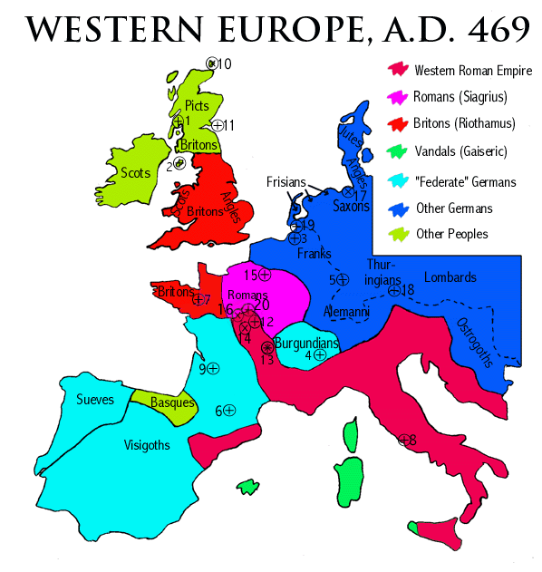

This time is of interest to the history of Britain because it is when Riothamus, the "king of the Britons" was campaigning in central Gaul against the Visigoths. It is a pity that this extraordinary piece of history, at a time when the Roman Empire in the West was on its last legs, is not better known.
Over the 60 years prior to this map, the Roman Empire had retreated greatly from its historical (from the 3rd century on) frontier, shown by the dashed line. By the time of the map, outside the Italian prefecture, the Empire held only parts of central and south-east Gaul, and north-east Spain. It did not even control the western Mediterranean any more. That sea, its islands (including western Sicily), and the African coast were all held by the Vandals, who were the implacable enemies of the Empire. An attempted invasion of Vandal Africa the previous year (468) by the Western and Eastern Empires had ended in ignominious failure, possibly through treachery.
Much of the rest of the former Imperial territory was occupied by Germanic tribes who were nominally federates of the Empire, but who in fact were independent of and often hostile to the Empire. These were the Sueves, the Visigoths and the Burgundians. Other Germanic tribes such as the Franks, Alemanni and Ostrogoths, had established territories that crossed the former Rhine and Danube frontiers. In Northern Spain the Basques, who had inhabited the region for millennia, were also independent once more.
This catalogue of successor states omits two which are unlike all of the others, and which here are coloured more similarly to the Empire.
The first of these is the realm of Siagrius. The son of Aegidius, the last master of the soldiers in Gaul, he had established an independent Roman state in North-West Gaul by 464. After the fall of the Roman Empire in the West in 476 he styled himself "king of the Romans", and was even acknowledged by the Franks as their overlord prior to Clovis' rise to power in 481. He was killed and his realm destroyed by Clovis in 486.
The second is the realm of Riothamus, the king of the Britons. We
actually
have very little idea of the extent of his authority. The regions
coloured
red here merely represent all of the areas probably controlled by
Britons
in 469 within former Imperial territory. But a fair proportion of
the
area ruled by Britons must have been subject to Riothamus, since he was
able to
muster
a fighting force ambitious enough to take on the Visigoths in Gaul.
Unfortunately,
the promised help from the Western Emperor Anthemius did not arrive in
time, and
Riothamus'
force (reportedly 12 000 strong) was routed by Euric at Deols. His
defeat
and death can only have hastened the disintegration of Britannia into
warring
tribes and statelets. Note that the Brittonic territory in Gaul is far
larger than usually assumed (the
Brittany peninsula), but is in line with the maps of Peter Salway's
It is interesting to speculate on what might have happened if the
battle
at Deols had gone the other way. In 469 the two non-Germanic and
pro-Roman
states of Siagrius and Riothamus, together with the Empire itself,
still
controlled close to half of the former Imperial territory in western
Europe.
Would an Imperial recovery have been possible? The reality was that the
Empire lacked the means, and the will to find the means, to defend
itself.
It continued to exist only on sufferance from the surrounding Germanic
states and its own almost entirely Germanic soldiery. The loss of all
Imperial
territory west of Italy by 477, following the forced abdication of
Romulus
Augustulus, was probably inevitable.