Between France and Germany:

16 Centuries of Europe's Middle Kingdoms


Text and maps copyright Howard Wiseman 2012.
Last Modified: 4th July 2014


The creation of the Empire of Charlemagne in 800 is the common point of origin for almost all the polities of continental Western Europe (*). This Empire itself arose from the incomplete fusion of the Germanic-speaking Franks with the Romance-speaking Gauls from c. 500 on. The incompleteness of the fusion became fully evident in 870 when the Empire was split into the West Frankish Kingdom (which became France) and the East Frankish Kingdom (which gave rise to Germany and the other German-speaking countries). This webpage however concentrates not on France and Germany, but on the countries in-between: Europe's Middle Kingdoms. In particular, it traces the history of the Burgundian lands, from the original 5th century Kingdom to its present political descendants: the Republic of Italy, the Kingdom of the Netherlands, and the Kingdom of Belgium (**).

Of course, there are many possible origin stories for these modern-day countries; tracing them back to the Burgundians is only one, and arguably not the most natural one. My best justification is that it gives a novel perspective on the last 16 centuries of political history in continental Western Europe, as the series of miniature maps below show. The (Burgundian-based) Middle Frankish Kingdom created for Emperor Lothar in 843 and disassembled on his death in 855 had been largely reassembled by Charles the Bold of Burgundy by 1475. But the tide of history was against him, namely the rising tide of France which reduced former Burgundian territory in the north to Belgium and the Netherlands, and pushed that in the south (Savoy) eastward into Italy. The dates for these maps (one every two centuries) are the same as those in the large-scale maps in the main part of the page, and are chosen to illustrate times of special interest in the history of Europe's Middle Kingdoms.

Kingdom of the Burgundians / Burgundy in 481, the accession of ClovisSub-Kingdom of Burgundy in the Frankish Kingdom in 614, when granted a Mayor of the PalaceThe Middle Frankish Kingdom at the treaty of Verdun in 843, based on Burgundy.Kingdom of Burgundy plus the Duchy of Burgundy in 1032Sub-Kingdom of Burgundy in the Holy Roman Empire, plus the Duchy of Burgundy in 1220Burgundy and Savoy, under Charles the Bold, 1475The Netherlands, the Burgundian Circle, and Savoy, treaty of Westphalia, 1648The Kingdoms of the Netherlands, Belgium, and Savoy, 1859The Netherlands, Belgium, and Italy, 2002


(*) That is, the countries west of Germany, Austria, and Italy, inclusive. The only significant polity with a wholly independent origin is Portugal, although Spain's origin is partially independent.
(**) The reader might be surprised that I don't list Switzerland here, since almost all of the territory of the present Swiss Confederation lay within the Burgundian Kingdom at most times from 460 to 1220. Politically, however, Switzerland grew from its western Canton of Schwyz, which was never in the Burgundian Kingdom. Moreover the dialect of German spoken in Switzerland, Allemanic, suggests a different link to the early middle ages. The omission of Switzerland is the chief difference in my narrative from that of Kelly Ross [7].

Return to Howard Wiseman's History page


Note: to view these maps as a coarse "movie", first adjust the size of this window to be slightly larger than a map plus its title, then click on next (>) or previous (<) at the beginning of each title. To return to the Index of Maps, click on the up arrow (^).

Index of Maps

481 -- The Accession of Clovis
614 -- The Edict of Paris
843 -- The Treaty of Verdun
1031 -- The Accession of Henry I, King of France
1219 -- The Appointment of the Last Rector of Burgundy
1475 -- The Zenith of Charles the Bold, Duke of Burgundy
1648 -- The Treaty of Westphalia
1859 -- The Treaty of Zürich
2002 -- The Eurozone is born
16 Centuries of Europe's Middle Kingdoms --- a Summary Map


^ > 481 -- The Accession of Clovis

Burgundians, Franks, Allemans, Siagrius' Romans
Burgundians, Franks, Allemans, and Siagrius' Roman Kingdom at Clovis' accession, 481

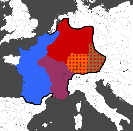
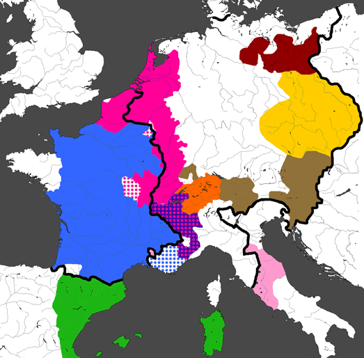
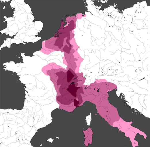
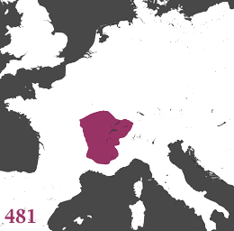
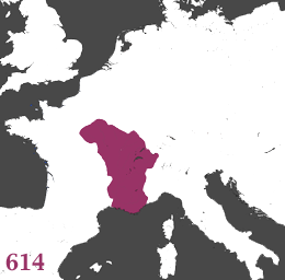
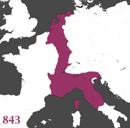
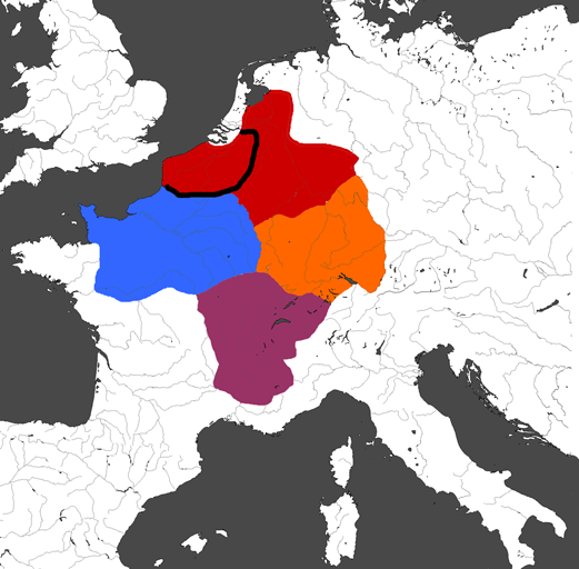
The fall of the Western Roman Empire is conventionally dated to 476, when the last Western Emperor acclaimed by the Senate in Rome was deposed and replaced by the Germanic King Odoacer. However, a realm ruled by a certain Siagrius, Rex Romanorum (King of the Romans) continued in northern Gaul, even though the Rhine frontier had been lost in the first decade of the 5th century. Siagrius' Kingdom would fall in 486 to the Frankish King Clovis. The accession of Clovis in 481 marks the beginning of the kingdom that would go to become the greatest of the Germanic kingdoms to succeed the Western Roman Empire. But at this time (481) Clovis was merely King of the Salian (sea-side) Franks, a territory indicated by the thick border. And at this time the territory of all the Franks, straddling the lower Rhine, was scarcely larger than that of two other Germanic Kingdoms which bordered Siagrius' realm: the Allemans straddling the upper Rhine, and the Burgundians in south-east Gaul. Moreover, bordering Siagrius' realm to the south was the much larger Kingdom of the Visigoths, encompassing Aquitaine (south-west Gaul), Septimania (southernmost Gaul), Provence (south of the Burgundian Kingdom) and almost all of Spain. It is not coloured because unlike the other polities indicated here, the Visigoths were wiped from the map by the Moslem conquest in the early 8th century, leaving neither political nor linguistic traces. Other polities in Gaul at this time --- also uncoloured because they cannot really be traced to independent nations in the present time --- are the Bretons to the west of Siagrius' kingdom, and the Frisians along the coast of the Netherlands.


< ^ > 614 -- The Edict of Paris

Neustria, Burgundia, Austrasia, Allemania, Bavaria
Kingdom of the Franks. Burgundia, Neustria, Austrasia, Edict of Paris 614 After defeating Siagrius in 486, Clovis conquered the Allemans in 497, took Aquitaine from the Visigoths in 508, and through murder and intrigue had become sole King of the Franks by his death in 511. He also campaigned against the Burgundians, but they were a tougher nut to crack. Burgundy was eventually conquered in 534 by three Frankish Kings --- two of them Clovis' sons and the third a grandson. For Clovis had partitioned his Kingdom between his sons upon his death, establishing a pattern that would continue for centuries. Nevertheless these Kings, and their successors, still regarded the Frankish realm established by Clovis as a unity, and if one King died without an adult heir (which was not unusual in those days of high mortality) his relative(s) would claim back his territory. This led to continually changing and often disjoint territories which paid little heed to the regional differences within the Frankish realm. This, amongst other things, led do a noble's revolt in 613 which made Clothar II sole King of the Franks. The following year he issued the Edict of Paris, giving greater power to the nobles and their regional centres of power, by creating three sub-Kingdoms, each administered by a Major Domus, a Mayor of the Palace. Neustria (the "New Land"), originally referred to the Gallo-Roman territory conquered from Siagrius, but at this time it also held loose control over Aquitaine. Burgundia was based on the original Burgundian kingdom but also included the region around Orléans, and Provence (ceded by the Goths in 537). Finally Austrasia (the "East Land") also included the Duchies of Allemania and Bavaria, the latter having been conquered in the mid 6th century.

< ^ > 843 -- The Treaty of Verdun

West Francia, Middle Francia, East Francia
Empire of the Franks, partition, treaty of Verdun 843 The administrative divisions of the Frankish realm persisted for 140 years, as real power shifted from the Kings to the Mayors of the Palace. Aquitaine became an independent Dukedom in 660, and two years later the rump of Neustria united with Burgundy. In 687, Pepin, Mayor of Austrasia, defeated the Mayor of Neustria and became sole governor of the Franks. His grandson, Pepin "the short", finally ended the royal line of Clovis, and the institution of Mayor of the Palace, by pronouncing himself King with papal approval in 752. His son, Charles "the great" (Charlemagne), well earned his epithet, greatly expanding the Frankish realm in all directions and being crowned "Emperor governing the Roman Empire" by the Pope in 800. However, this elevation did not stop Charlemagne from planning to partition his Empire between his sons as was the Frankish custom. But all of his sons predeceased him bar Louis "the pious", who inherited the Empire more-or-less intact on Charlemagne's death in 814. Even before Louis' death in 840, his three sons were fighting over their inheritance, and a settlement was not reached until the Treaty of Verdun in 843. The eldest son, Lothar, received Middle Francia – most of Italy, most of Burgundy, and "Lotharingia"(*) in the north including Charlemagne's capital of Aachen – plus the Imperial title, and a nominal sovereignty over his brothers: Charles "the bald" of West Francia and Louis "the German" of East Francia. As well as thus creating France and Germany, the nations which still dominate Western Europe to the present day, this agreement (actually the antecedent Oath of Strasbourg of 842) contains the first recorded example of Old French (as a distinct language from the Latin preamble) in Charles' address to his troops, and a very early example of Old High German in Louis' address to his troops.

(*) actually named after Lothar's son Lothar II, who inherited it.


< ^ > 1031 -- The Accession of Henry I, King of France.

[Isle de France], Duchy of Burgundy, Kingdom of Burgundy, [Holy Roman Empire], Papal States, Catalan Counties
Isle de France. Catalan Counties. Duchy of Burgundy. Kingdom of Burgundy. Holy Roman Empire. 1031 Middle Francia was partitioned into its three parts (Lotharingia, Burgundy, and Italy) on Lothar's death in 855. The first and last of these were annexed by East Francia in 880 and 951 respectively. East Francia had come to be known as Germany since it came under the rule of a Saxon House when Henry "the fowler" was elected King in 919. His son Otto "the great" made the further leap to Emperor in 962, as the last descendant of Charlemagne holding that title had died in 924. It is convenient to call this reborn Empire by its later (1254) title of Holy Roman Empire. Otto was crowned by the Pope, who received land around Rome in return, which however remained part of the Empire. Although the modern remnant, the Vatican, is too small to be seen on these maps, the Papal States played an important role in the politics of western Europe for 900 years. (Another autonomous polity within the the official borders of the Empire was the city of Pisa and its dependencies, the nearby islands of Corsica and Sardinia, which are uncoloured.) Meanwhile, the Burgundian part of Lothar's Kingdom, having long been treated merely as a pawn in the game of claiming the Imperial crown, reemerged as a stable Kingdom of Burgundy in 933. I use a bluish tint for this Kingdom because another polity also survived with he Burgundian name: the Duchy of Burgundy (indicated with a pinkish tint), which had become part of West Francia in 843. By 987, when the dynasty descended from Charlemagne came to an end, West Francia (by then known simply as Francia, or France) had become a kingdom in name only. The new House of Capet properly ruled only the region around Paris, the Isle de France, as Bretons, Norman settlers, and over-powerful nobles took control of the rest of the kingdom. The French king Robert II claimed the Duchy of Burgundy in 1004, but passed it to his son Henry in 1016. In 1031, when Henry I became King of France, he brought the Duchy into the royal domain once more (hence the blue dots). Another notable polity within the official borders of France was the group of Catalan Counties dominated by Barcelona. These counties had refused to recognize the Capetian dynasty, and so must be counted as effectively independent since 987.

< ^ > 1219 -- The Appointment of the last Rector of Burgundy

[France], Duchy of Burgundy, Kingdom of Burgundy, [Holy Roman Empire], Bohemia, Papal States, Aragon
France. Catalonia, Duchy of Burgundy. sub-Kingdom of Burgundy. Holy Roman Empire. Bohemia. 1219 The Duchy of Burgundy remained a possession of the French king for only a year: Henry I granted it to his brother Robert in 1032, and he and his descendants were to rule as Dukes for more than three centuries. In that same year, the Kingdom of Burgundy also changed its status, but in the opposite direction: when Rudolph III, King of Burgundy, died childless, he left the kingdom to the Holy Roman Emperor, Conrad II. Burgundy, or Arelate as it became known after its capital of Arles, remained a kingdom in name, becoming one of the three constituents of the Empire. But the Emperors were always more interested in the other two kingdoms, Germany and (northern) Italy. In 1127, Emperor Lothar III handed the regal powers in Burgundy to a German Duke, Conrad. Conrad styled himself ''Duke and Rector of Burgundy", but later Emperors tried to limit the power of his dynasty. When Conrad's grandson died without issue in 1218, the title of Rector was conferred upon the seven-year-old Henry, eldest son of the (as yet uncrowned) Emperor Frederick II (hence the red dots in the Kingdom of Burgundy). Meanwhile, a fourth Kingdom had been created within borders of the Empire: the Kingdom of Bohemia. This had become autonomous under King Ottokar in 1198, and the future Emperor Frederick II confirmed its status as an hereditary monarchy on his accession in 1212 as King of the Romans (a title actually meaning King of Germany) and King of Italy. Frederick II was to be the first Holy Roman Emperor to nominally rule all of Italy --- he had inherited the Kingdom of Sicily (which included southern Italy) in 1198 --- and he modelled himself on the ancient Roman Emperors. But he would spend much of his long reign (until 1250) trying to enforce his rule there. He was opposed both by the Popes, who were extending the Papal States and feared nothing more than being surrounded by Imperial arms, and by the increasingly affluent mercantile cities of northern Italy. While the power of the Emperor was waning, that of the King of France, Phillip Augustus, was waxing. While the Royal Domain was still only a fraction of the area within the official borders of France, at least now it was larger than that of any of the King's rivals. Moreover, those official borders were expanding at the expense of the Kingdom of Burgundy. However across the Pyrenees, Catalonia had definitively separated from France. Count Ramon IV of Cataloniabecame the Prince Regent of Aragon (to the west) through marriage in 1137. His son Alfonso II, who succeeded in 1164, chose the title King of Aragon as ruler of the united realm.


< ^ > 1475 -- The Zenith of Charles the Bold, Duke of Burgundy

France, Burgundy, Duchy of Savoy, [Holy Roman Empire], Swiss Confederation, Austria etc., Bohemia, Brandenburg, Papal States, Aragon
France, Aragon, Burgundy, Charles the Bold, Holy Roman Empire, Bohemia, 1475 When Emperor Frederick II was crowned by the Pope in 1220, his son Henry was elected King of the Romans (i.e. King of Germany and heir to the Empire), and dropped the title of Rector of Burgundy. Thereafter there was no attempt to govern Arelate as a single unit. As Imperial power weakened from the later 13th century onwards, the increasingly powerful Kings of France further extended the borders of France eastward into Arelate, and brought Provence under their influence. The remainder of the ex-Kingdom of Burgundy was dominated by the County of Savoy. Count Amadeus VI was named Imperial Vicar for the Kingdom of Arelate in 1365, and in 1416 the County became the Duchy of Savoy. Imperial weakness also led to full independence for the (still growing) Papal States in 1282, and to the gradual development of autonomy for, amongst others, the Swiss Confederation (founded in 1291), the Electorate of Brandenburg (a status granted in 1356 meaning that the Margrave of Brandenburg would be one of those who elected the Emperor), and the Arch-Duchy of Austria (self-proclaimed in 1358, after the Duke of Austria was not raised to the status of an Elector) and its dependencies under the Hapsburgs. By the time of this map, the Hapsburg Frederick III had been Emperor since 1440, and the title would be held by his descendants until 1806 (apart from 1742-5). As Colin McEvedy [4] wrote, the Electors were prepared to allow this monopoly on the Imperial throne "because its possession was a source of weakness rather than strength." This weakness was most evident on the western borders of the Empire, where, starting in 1384, the Valois Dukes of Burgundy (in France) acquired an extensive array of territories by marriage alliance and purchase. This included the Free County (Franche Comté) of Burgundy (that part of the ex-Kingdom of Burgundy immediately to the east of the Duchy), much of what had once been Lotharingia (see 843), as well as Flanders and Picardy in France. Collectively, all of these territories were known as Burgundy, and made the Dukes one of the wealthiest monarchs in Europe. The last of them, Charles "the bold" (1467-77) aimed at nothing less than the revival of Lothar's Middle Kingdom. He effectively controlled numerous neighbouring Bishoprics and Principalities (these are shown in Burgundian colour in the map, which also somewhat simplifies the convoluted borders). He had subjugated and planned to annex Savoy (effectively under the rule of the Valois Duchess Yolande) [9], and Nevers to the west (under the Valois Count John) was nominally his vassal. In 1473 Charles nearly managed to force the Emperor Frederick III to grant him the title King of Burgundy. Burgundian territory reached its peak in 1475, with Charles' conquest of Lorraine (the southernmost part of Lotharingia, which still retained the ancient name). For the first time since 855, there was a realm between France and Germany whose power extended from the North Sea to the Mediterranean.


< ^ > 1648 -- The Treaty of Westphalia

France, Netherlands, Burgundian Circle, Duchy of Savoy, [Holy Roman Empire], Swiss Confederation, Austria etc., Brandenburg, Papal States, Spain etc.
Burgundian Circle, Savoy, Treaty of Westphalia, Holy Roman Empire of the German Nation, 1648 The ambitions of Charles the Bold alarmed Louis XI of France, who financed the Swiss and the ousted Duke of Lorraine to make war upon him and Savoy. In 1477, Charles, living up to his epithet, was killed in a reckless attempt to retake Nancy in Lorraine. He had no sons, and his only daughter Marie was unmarried, so his Middle Kingdom died with him. The Duke of Lorraine regained his Duchy, and Louis XI invaded the other Burgundian territories. But Marie agreed to marry Maximilian, heir of the Hapsburg Emperor Frederick III, to try to preserve her inheritance. In this way, Emperor Maximilian of Austria ended up ruling most of the Burgundian territories within the Empire, as well as extending the Empire's border to encompass Flanders and Picardy. These former Burgundian territories now under Hapsburg rule were known as the Burgundian Circle, one of ten Imperial Circles (regions) set up for taxation and governance in 1512. Marie and Maximilian's son Phillip meanwhile had married Joanna the Mad, daughter of Ferdinand of Aragon and Isabella of Castilla. Phillip and Joanna's eldest son Charles had inherited all of his grandparent's territories by 1519 --- Spain and its growing Empire in Italy and the New World, the Burgundian Circle, and Austria --- as well as the Imperial title. But he faced stiff opposition from an alliance between the Ottoman Empire and France. The latter had finally become a unified Kingdom (apart from a few tiny territories) when Francis, recently married to Claude, heiress of Brittany, ascended to the French throne in 1514 (*). To deal with this threat on all sides of his Empire, Charles made his brother Ferdinand Archduke of Austria in 1521. By 1556, when Charles abdicated, Ferdinand had brought Bohemia and western Hungary into the Austrian fold. Ferdinand kept these and gained the Imperial title, while Charles' son Phillip II got the rest, including the Burgundian Circle. This Circle had been extended in the north in 1548 but in 1566 these northernmost subjects of Spain, and their fellow Protestants around the Zuiderzee, rebelled. Their struggle for independence from Spain lasted 82 years, the last 30 of which were part of the terrible 30-years war which laid waste much of the Empire. It ended with the 1648 Treaty of Westphalia, which saw a major contraction in the Empire. It had been known as the Holy Roman Empire of the German Nation since 1512, and the new boundaries of the Empire reflected this, ending the fiction of Imperial power in northern Italy, Savoy, Switzerland, and the United Provinces of the Netherlands. But the greater part of the Burgundian Circle remained within the Empire, under Spanish rule (hence the green Spanish dots on the original Burgundian colour). Spain also kept the Kingdom of Naples (held by Aragon since 1504) and the Duchy of Milan (held since 1535).

(*) As a consequence the official borders of France are no longer shown on the map.

< ^ > 1859 -- The Treaty of Zürich

French Empire, Netherlands, Belgium, Kingdom of Sardinia, [German Confederation], Swiss Confederation, Austrian Empire, Prussia, Papal States, Spain
Treaty of Zürich, 1859, Savoy, Kingdom of Sardinia, Victor Emmanuel, German Confederation, United Provinces of Central Italy The Franche Comté of Burgundy, the southernmost part of the Burgundian Circle, was annexed by France in 1678, and around the same time the French pushed their border west to the Rhine and regained Picardy in the north. Following the war of the Spanish succession (which put a Bourbon King on the throne of Spain) the remaining part of the Burgundian Circle was transferred to the Austrian Hapsburgs in 1713. But for some, the dream of the Middle Kingdom would not die: Charles Thomas, Elector of Bavaria, tried to trade Bavaria for these Austrian Netherlands and the title "King of Burgundy" in 1778 and again in 1784. The French revolution and Napoleon's victories swept aside the relics of medieval polities and institutions across Europe. These including the Holy Roman Empire, which in its act of auto-dissolution in 1806 referred to itself merely as the German Confederation. Following Napoleon's defeat, the map of Europe was once again redrawn by the Congress of Vienna in 1815. The German Confederation was reformed but it was completely dominated by the two great powers which had grown in the lebensraum on its eastern frontier: Austria (an Empire since 1806) and Prussia (formerly Brandenburg, and a Kingdom since 1701). The German Confederation also excluded, mostly, the former Austrian Netherlands which were added to the United Provinces to create (it was hoped) a strong buffer against France. The exception was the south-western corner (Luxembourg) which was part of both the German Confederation and the new Kingdom of the Netherlands. But the former Hapsburg subjects, both French and Flemish speaking, objected to rule by the northerners, and revolted in 1831. The final settlement in 1839 saw international recognition for the Kingdom of Belgium (named after the Gallic tribe Julius Caesar had said was a mixture of Celts and Germans), with the Kingdom of the Netherlands keeping only two small provinces beyond its pre-Napoleonic borders: Maastricht and the western part of Luxembourg. The border of the German Confederation was adjusted to exclude the eastern part of Luxembourg which had gone to Belgium, but to include Maastricht. To the south, meanwhile, the Congress also strengthened the Kingdom of Sardinia (as Savoy had been known since it annexed Sardinia in 1720) as another buffer state against France, by granting it Genoa. The original County of Savoy had been French (or, more accurately, Franco-Provençal) speaking, but over the centuries its eastward drift had made the Kingdom of Sardinia predominantly Italian. And with the growth in nationalism fostered by Napoleon, Italians were no longer content to live in half a dozen major states (plus some tiny ones), nor to have Lombardy and Venetia in the north ruled by Austria (which had been the case since 1815). In 1859, Emperor Napoleon III of France and King Victor Emmanuel II of Sardinia drove the Austrians out of Lombardy, which Austria ceded (to France, which immediately transferred it to Sardinia) in the Treaty of Zürich. Meanwhile, the people of Tuscany, Parma, and Modena had expelled their Princely rulers and organised themselves into the United Provinces of Central Italy. They occupied the northern parts of the Papal States, and accepted a Governer General from Sardinia.

< ^ 2002 -- The Eurozone is born

France, Netherlands, Belgium, Italy, [Eurozone], Luxembourg, Swiss Confederation, Austria, Germany, Czech republic, Spain
Eurozone 2002 The unification of northern and central Italy under Sardinia was not what Napoleon III had wanted, and he was persuaded to allow a plebiscite in the United Provinces of Central Italy in 1860 only when Victor Emmanuel ceded to France the regions of Savoy and Nice --- the last remnants of the once Kingdom of Burgundy ruled by the House of Savoy. The Central Italians voted overwhelmingly for union with Sardinia and by 1870 all Italian-speaking lands (except Corsica) had been united under Victor Emmanuel, King of Italy. In that same year Prussia trounced France, having already trounced Austria in 1866 and abolished the German Confederation. With one exception, all of the German-speaking states bar Austria were persuaded to unify with Prussia to form the German Empire in 1871, and this artificial division between Germany and Austria persists to the present. The one exception was the Grand Duchy of Luxembourg, in the heart of the original Frankish territories and coloured to suit, which became independent (Dutch-speaking Maastricht stayed with the Netherlands). In 1919, following the First World War, the Austrian Empire was dismembered, but the process of disintegration did not finish until 1993, when the Czech republic was born, almost identical in its extent to the Kingdom of Bohemia of 1198. Meanwhile in 1945, in the aftermath of the Second World War, the frontiers of Poland had also been restored to those of eight centuries earlier, with eight million Germans repatriated from east of the Oder-Neisse line. To prevent a repeat of the terrible carnage of the two World Wars, the governments of western Europe dedicated themselves to forming an ever closer economic, cultural, and political union. The European Union (EU) has spread to encompass the overwhelming majority of European countries west of Russia, Belarus and Ukraine. But within the EU there is the smaller common-currency Eurozone. When the physical currency, the Euro, was launched in 2002, the Eurozone comprised the coloured countries surrounded by the black border in the map, plus the four corners of the EU (off the map): Greece, Portugal, Ireland, and Finland. Not counting those four countries, and ignoring the aloofness of Switzerland, the original core of the Eurozone corresponds well to Charlemagne's Empire of twelve centuries earlier. This is hardly a coincidence. Moreover, the de facto capital of the EU is Brussels, capital of Belgium, still the Middle Kingdom between France and Germany.


16 Centuries of Europe's Middle Kingdom(s) --- a Summary Map

Burgundy, Middle Kingdoms, Italy, Belgium, the Netherlands This map summarizes the areas ruled by Europe's Middle Kingdom(s) --- i.e. those coloured like Italy, Belgium, or the Netherlands above --- over the last 16 centuries. The depth of the colour indicates how many times that region appears within a Middle Kingdom in the nine maps above. No region appears in all nine maps.

The darkest shade corresponds to areas that appear in seven of the above maps. There are three such regions, from north to south: Franche Comté, Savoy (which appears in eight), and Nice. Savoy was at the heart of the original Burgundian settlement in Gaul in 443, so it is fitting to find it the most persistent part of the Middle Kingdoms.

The dark shade shows areas that appear in five of the above. There are two such regions. The odd-shaped region in the north encompasses much of Belgium and the Netherlands. The larger region in the south is the core of the Burgundian Kingdom, with an extension over the Alps reflecting the expansion of the Duchy of Savoy into Italy.

The light shade is for areas that appear in at least two maps. It is necessary to go this far to unify the northern and southern regions into a single region. It encompasses (i) the whole of Italy north of Rome, (ii) a large Burgundian region west of the Alps, (iii) the whole of Belgium, and the Netherlands, and (iv) a narrow strip of connecting territory including Luxembourg between (ii) and (iii).

The lightest shade is what appears in any of the maps. This extends the preceding region to include the whole of Italy, the area around Orléans, a much wider connecting strip stretching as far east as the Rhine for most of its length, plus Picardy and the north-west coast of Germany.

Given that I have characterized the Middle Kingdoms as lying between France and Germany, the most remarkable feature of this map is how much of their territory has been absorbed by France, and how little by Germany. Indeed, if one considers areas appearing in six or more of the above nine maps, one finds that all such areas are contained within the present borders France. This is no longer true if one considers those appearing in five or more (the dark shade), but not because some of these areas are within Germany, but rather because some are within the successor states of Italy, Belgium, and the Netherlands.

Selected Bibliography

  1. András Bereznay (map-maker), The Times Atlas of European History (Time, London, 1994).
  2. H. Kinder and W. Hilgemann, The Penguin Atlas of World History, Vol. I (Penguin, London, 1978).
  3. Colin McEvedy, The New Penguin Atlas of Medieval History (Penguin, London, 1992).
  4. Colin McEvedy, The Penguin Atlas of Modern History (to 1815) (Penguin, London, 1972).
  5. I. Mladjov, Burgundy, sitemaker.umich.edu/mladjov/files/burgundian_rulers.pdf
  6. Christos Nüssli, Historical Atlas of Europe, http://www.euratlas.net/history/europe (2009).
  7. Kelly Ross, Successors of Rome: Francia (447-Present), http://www.friesian.com/francia.htm (2012).
  8. François Velde, The Holy Roman Empire, http://www.heraldica.org/topics/national/hre.htm (Feb 13, 2008).
  9. Richard Vaughn, Charles the Bold: The Last Valois Duke of Burgundy (Longman, London, 1973).

Return to Howard Wiseman's History page